| Research
James River Ecosystem Study ||
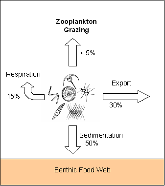
Restoration of Kimages Creek James River Ecosystem Study The James is the nation’s most historic river serving as the site of the first permanent colonial settlement and the earliest stages of export agriculture and industrial activity. The river drains a large portion of Virginia originating in the Appalachian Mountains and flowing eastward for 540 km before entering Chesapeake Bay. The river plays an important role in the regional economy serving as a major transportation artery, a drinking water source for a growing population in the Richmond metro area and a premier recreational fishery and white-water destination. Water quality and biotic resources are well characterized (particularly nutrients and fish) although little work has been done to investigate lower trophic levels (plankton) and ecosystem processes. Preliminary studies revealed a “hot spot” of biological production located at approximately river mile 75 and near the VCU Rice Center. At this location, chlorophyll concentrations and rates of primary production are substantially higher than those observed in the upper (non-tidal) river or in the lower (saline) estuary. My first question was to ask why this particular location supported such high algal abundance. Results from river surveys and laboratory bioassay experiments suggest that light availability plays an important role. The location of the chlorophyll maximum is at the point where the James transitions from a deep, narrow channel to a broad, shallow expanse. Shallow waters provide more favorable light conditions because phytoplankton spend more time near the surface where underwater irradiance is higher. Phytoplankton in this segment of the James likely also benefit from their proximity to outfalls of wastewater treatment plants from the Richmond metropolitan area. My second question was to ask what happens to the algal biomass produced in this segment of the river. Is it utilized locally or exported via tidal exchange to subsidize food webs outside the area of peak production? Estimates of ecosystem metabolism based on continuous monitoring of dissolved oxygen at the Rice Pier suggest that the bulk of new production (ca. 70%) is utilized locally (see digram below). However, we were surprised to find that measured rates of zooplankton grazing were very low; less than 5% of algal biomass per day. We do not fully understand why zooplankton are not exploiting the available food resources more fully. The chlorophyll maximum occurs near the start of the estuarine turbidity maximum. Therefore while algal abundance is high, the proportional contribution of algae to suspended particulate matter is low and poor food quality may constrain zooplankton production. Overall, the lines of evidence suggest that little of the algal production in this hot spot is directly transferred to the pelagic food chain and yet this segment of the James is known for its productivity (e.g., of fisheries and fish-eating birds such as osprey and bald eagles). The bulk of algal production sinks and enters the benthic food web. We are currently measuring sedimentation rates and searching for the food chain components that link pelagic phytoplankton production to higher trophic levels.
|